History of Kamensk Shakhtinsky. Where is Kamensk located? Architectural features of the city
There are no cities in Russia that would not have interesting and remarkable places. Even locality young, then the architects will certainly bring a twist to the overall gray picture. Kamensk-Shakhtinsky is one of those cities that have a rich history dating back hundreds of years, which is why tourists here will be especially interested. Where to go and what to see in Kamensk-Shakhtinsky?
Information about the city
Kamensk-Shakhtinsky is a city in the Rostov region, located 142 kilometers from Rostov-on-Don and 932 kilometers from Moscow.
It got its name from the river flowing nearby (Malaya Kamenka) and the main specialization of the settlement - coal mining in mines. The population is about 89.5 thousand people.
Interestingly, the city has at its base two streets perpendicular to each other (Karl Marx Avenue and Lenin Street), which are located in the cardinal directions.
Kamensk-Shakhtinsky began its history as the village of Kamenskaya, the first mention of which dates back to 1671. At the end of the 20s of the XX century, the village was finally renamed first into the city, and then into Kamensk-Shakhtinsky.
During the Great Patriotic War, the settlement was occupied, now many sights of Kamensk-Shakhtinsky, Rostov Region, are dedicated to its liberators.
Architectural features of the city
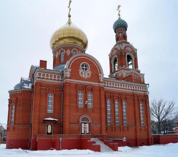
Church of the Intercession Holy Mother of God- a small and cozy building with distinctive features: an onion dome, a combination of colors, a bell tower. The laying of the structure began in 1991, and the opening took place 12 years later, in 2003. Address: Bashkevich lane, 85. Near this place in 1914 they wanted to build a church, but due to the revolution it was not completed and was dismantled. On this moment that place is marked with a memorial cross, which is also a landmark of Kamensk-Shakhtinsky.
The school building on Karl Marx Avenue, 26 is famous for its rich history which is over 130 years old. It housed not only a school, but also a gymnasium, communications offices, and a telegraph office. At one time, important military, cultural and political figures of the country studied there, including M. Grekov, I. Kosonogov, K. Trenev, in honor of the latter, a memorial plaque was installed on the building.
Memorable sights of Kamensk-Shakhtinsky

During the occupation of the city by the Nazis, local pioneers did not stand aside. They kept track of where the combat points of the enemies, warehouses with weapons were located. When the Red Army entered Kamensk-Shakhtinsky, the boys told the information about the enemies that they managed to collect, however, due to the fact that there were few Soviet soldiers, they were quickly thrown back out of the city, and the Nazis grabbed the schoolchildren and shot them in the basement of the building Gymnasium No. 12 (previously there was a school). In their honor, in 1967, a monument-stele "To Pioneer Heroes" was erected, an important landmark of Kamensk-Shakhtinsk. Address: Arsenalnaya street, 2.
An unusual monument was the stele dedicated to the dead motorcycle racers, located near the Bike Hotel on Geroev Pionerov Street, 91. The monument is a 10-meter statue consisting of motorcycles aimed at the sky. The location of the stele allows it to be seen from the M-4 Don highway, where accidents with motorcycle drivers often occur; it is an unspoken reminder that life is more important than speed.
Where can you walk, learn something interesting or relax?

Many of the guests of the city stay at local hotels, one of which has become not only a place of temporary residence, but also a thematic museum. Each room of the hotel "USSR" brings its visitors back to the times of childhood and youth, and in the exhibition hall of the hotel there are retro cars, motorcycles, bicycles, weapons, coins, as well as utensils. Both hotel clients and ordinary citizens can visit the museum at the address: Heroes-Pioneers Street, 91-v.
The Kamensky Museum of Arts and Crafts and Folk Art is itself a landmark of the city of Kamensk-Shakhtinsky: the building was used by the Don Cossacks during the revolutionary events, and it has survived to this day. Location: Karl Marx Avenue, 56. The museum's collection includes 15 exhibits related to the history of the city and its culture. Of particular interest to visitors are exhibits of archeology, numismatics, weapons and arts and crafts.
In one of the districts of the city district there is a landscape park "Loga". Kamensk-Shakhtinsky, whose photo will cause a sincere desire to visit it. The park area is located on 22 hectares, which were previously occupied by a landfill. This place is a living proof that with love and patience it is possible to make a flowering garden even from an arid area. In addition to a lot of greenery, in the park you can see sculptures, a rock garden, waterfalls and lakes, gazebos and benches, crooked mirrors, fairy-tale characters, a musical fountain, cozy cafes, restaurants and much, much more. Address: Farm Staraya Stanitsa, st. Bolshevik 77.
Thus, the sights of Kamensk-Shakhtinsky are very diverse: architecture, monuments, museums, parks - any guest of the city will find something interesting for himself!
The city of Kamensk-Shakhtinsky is located on the territory of the state (country) Russia, which in turn is located on the territory of the continent Europe.What federal district does Kamensk-Shakhtinsky belong to?
Kamensk-Shakhtinsky is included in the federal district: Southern.The Federal District is an enlarged territory, consisting of several subjects of the Russian Federation.
What region is Kamensk-Shakhtinsky located in?
The city of Kamensk-Shakhtinsky is part of the Rostov region.A characteristic of a region or a subject of a country is the possession of the integrity and interconnection of its constituent elements, including cities and other settlements that make up the region.
The Rostov region is an administrative unit of the state of Russia.
The population of the city of Kamensk-Shakhtinsky.
The population in the city of Kamensk-Shakhtinsky is 89,657 people.Year of foundation of Kamensk-Shakhtinsky.
Year of foundation of the city of Kamensk-Shakhtinsky: 1671.What is the time zone in Kamensk-Shakhtinsky?
The city of Kamensk-Shakhtinsky is located in the administrative time zone: UTC+4. Thus, you can determine the time difference in the city of Kamensk-Shakhtinsky, relative to the time zone in your city.Telephone code of the city Kamensk-Shakhtinsky
Telephone code of the city of Kamensk-Shakhtinsky: +7 86365. In order to call the city of Kamensk-Shakhtinsky from a mobile phone, you need to dial the code: +7 86365 and then directly the subscriber's number.Official site of the city of Kamensk-Shakhtinsky.
Website of the city of Kamensk-Shakhtinsky, official website of the city of Kamensk-Shakhtinsky or as it is also called "Official website of the administration of the city of Kamensk-Shakhtinsky": http://kamensk.donland.ru.On the map of Russia, Kamensk-Shakhtinsky is located in the Rostov region.
The city was founded in 1671, but received official status only in 1927.
The area of Kamensk-Shakhtinsky is about 160 square kilometers.
The population is about 90 thousand people.
Kamensk-Shakhtinsky on the map of Russia, where it is located, nature and climate
The city is located on the right bank of the Seversky Donets River, at the northeastern spurs of the Donetsk Ridge, 140 kilometers from Rostov-on-Don and 415 kilometers from Krasnodar.
The climate is steppe, temperate continental. The average air temperature in winter is from -5 to -10, in summer - from +26 to +28. There is little rainfall during the winter months.
Not far from Kamensk-Shakhtinsky there is the village of Chistoozerny, where there is a lake called "Eldorado". There is also a recreation center of the same name and a beach with a paid entrance.
Routes on the map of Kamensk-Shakhtinsky. Transport infrastructure
Public transport in the city - these are various buses running on two dozen routes, as well as taxis. There are four "seasonal" routes by which city residents get to their dachas in gardening associations.
Federal highways pass through Kamensk-Shakhtinsky M4 Don» Novorossiysk - Moscow and « E40» Chisinau - Volgograd.
The city has two stations of the North Caucasian railway ― Kamenskaya And Dashing.
The nearest airports are located in Lugansk(90 km), Rostov-on-Don(150 km) and Taganrog(190 km).
Sights of the city Kamensk-Shakhtinsky
- Thematic museum "Legends of the USSR", the exposition of which is dedicated to various Soviet technology.
- Museum of Decorative and Applied Arts and Folk Art, where items of Cossack life, items made of precious metals, weapons, archives of participants are collected civil war, icons, etc.
- Stele near the Bike Hotel, erected from motorcycles in memory of the dead bikers.
- Church of the Holy Trinity Life-Giving, the Church of the Intercession of the Holy Mother of God and the Church of All Saints are the main religious monuments of the city.
- Leisure park them. Gorky(former city garden) and recreation park. Mayakovsky, where the "House of Nature" is located - the local history museum of nature of the Don region.
- Monument to the Don Cossacks who took part in the War of 1812.
Among the catering establishments on the northern side of the city, the Zhavoronok and Arabica cafes, and the Olimp restaurant stand out. On the south side there are cafes "Armenian Cuisine", "Alliance" and "Broadway", bistro "Baggis No. 5".
To search for a particular institution, it is better to use a map of Kamensk-Shakhtinsky from a satellite.
Economy and industry of Kamensk-Shakhtinsky
In accordance with the name of the city, the main enterprises are associated with the extraction of coal.
There are two chemical plants - " Kamenskvolokno”, engaged in the production of viscose fiber, and“ Kamensky, which manufactures polymers.
Enterprises of heavy and light industry: machine-building, oil refinery, glass container, woodworking and brick factories, as well as a gas-using equipment plant and the Gloria Jeans textile factory.
Food enterprises: a bakery, a confectionery factory, a dairy plant, a meat processing plant.
There are branches of well-known retail chains Pyaterochka, Citylink, Eldorado, Gloria Jeans, Magnit and Fix Price in the city. To find the necessary store, you can use the map of Kamensk-Shakhtinsky with the streets.
Financial institutions in Kamensk-Shakhtinsky: branches of Sberbank, Rosselkhozbank, Promsvyazbank, OTP Bank, Rosgosstrakh Bank, Post Bank, etc.
Quite a few new apartment buildings are being built in the city, as the population is declining every year. As a result, real estate is very cheap. For example, a three-room apartment can cost only two million rubles.
Using the map of Kamensk-Shakhtinsky with houses, you can easily find the address where this or that apartment is being sold.
Located on the banks of the Seversky Donets River, 190 kilometers from the regional center. The area of the settlement is 160 square kilometers.
General data and historical facts
In 1671, a Cossack settlement arose near the Malaya Kamenka River. In 1817, most of the inhabitants of the village moved to the place where the modern city is now located.
In the first half of the 19th century, parochial and four-year schools were opened in the village.
At the beginning of the 20th century, the village of Kamenskaya became the largest of the Don capitals. At this time, a real school, men's and women's state gymnasiums began to function in Kamenskaya.
In January 1918, the Don Cossack Military Revolutionary Committee was formed in the village, headed by F. G. Podtelkov and M. V. Krivoshlykov.
From 1920 to 1924 Kamenskaya was part of the Donetsk province of the Ukrainian SSR. In the spring of 1927, Kamenskaya was transformed into the city of Kamensk. Two years later, the city was renamed Kamenskoye-Shakhtinsky.
From July 1942 to February 1943 the city was under the occupation of the Nazi invaders.
In February 1943, the 5th Panzer Army was able to liberate the settlement from the Nazi troops.
In 1960 in Kamensk-Shakhtinsky was built a large number of apartment buildings and social and administrative facilities.
In August 1987, the city was hit by a major rail accident that killed 106 people.
Industrial enterprises of the city: FKP "Combine Kamensky", PJSC "Kamenskvolokno", PJSC "Machine-building Plant", OJSC "Kamensky Oil Refinery", LLC "Kamensky Plant of Gas-Using Equipment", Kamenskaya CHPP, brick and woodworking plants.
The telephone code of Kamensk-Shakhtinsky is 86365. The postal code is 347800.
Climate and weather
A temperate continental climate prevails in Kamensk-Shakhtinsky. Winters are long and moderately cold.
Summer is very warm and dry. The warmest month is July - the average temperature is +24.7 degrees. The coldest month is January - the average temperature is -5.8 degrees.
The average annual rainfall is 470 mm.
The total population of Kamensk-Shakhtinsky for 2018-2019
Population data obtained from the State Statistics Service. Graph of changes in the number of citizens over the past 10 years.

The total population for 2017 was 89.6 thousand people.
The data from the chart shows a slight drop in population from 95,700 in 2006 to 89,657 in 2017.
As of January 2018, in terms of the number of residents, Kamensk-Shakhtinsky ranked 192 out of 1113 cities of the Russian Federation.
Attractions
1.Stella at the "Bike Hotel"- this steel structure is made in the form of a pillar to which numerous motorcycles are attached. The stele was erected in memory of the dead bikers.
2.Landscape park "Loga"- this corner of nature was opened in 2012 according to the project of designer S.A. Kushnarenko.
3.Lake Eldorado- a picturesque place of rest is located 12 kilometers from Kamensk-Shakhtinsky.
Transport
In Kamensk-Shakhtinsky there are several railway stations, which connect the city with Belaya Kalitva, Millerovo, Mines, Novocherkassk, Aksay, Rostov-on-Don, Krasny Sulin.
Public transport consists of buses and minibuses.
From the bus station of the city there are regular buses to Moscow, Rostov-on-Don, Taganrog,
Here is a map of Kamensk-Shakhtinsky with streets → Rostov Oblast, Russia. We study detailed map Kamensk-Shakhtinsky with house numbers and streets. Real time search, today's weather
More about the streets of Kamensk-Shakhtinsky on the map
A detailed map of the city of Kamensk-Shakhtinsky with street names shows all routes and objects, including the street. Shchadenko and Gagarin. The city is located near. Near the river Seversky Donets.
For a detailed study of the territory of the entire region, it is enough to change the scale of the online scheme +/-. On the page is an interactive map of the city of Kamensk-Shakhtinsky with addresses and routes of the microdistrict. Move its center to find Lenin and Ukrainskaya streets. Also, the ability to lay a route through the territory is the “Ruler” tool, and find out the length of the city.
You will find everything you need detailed information o location of urban infrastructure - shops and houses, squares and roads.
Satellite map of Kamensk-Shakhtinsky (Kamensk-Shakhtinsky) with Google search is waiting for you in its rubric. You can use the Yandex search to find the necessary house number on the map of the city in the Rostov region of Russia in real time. With help - will help you find the right home. st. Kirova and Yuzhnaya will help you navigate the territory.
Coordinates - 48.3216,40.2686


